

![]() The connected vehicle data pioneer, has introduced two different connected vehicle datasets for the entire US: Wejo Journeys and Wejo Events.
The connected vehicle data pioneer, has introduced two different connected vehicle datasets for the entire US: Wejo Journeys and Wejo Events.
Wejo Journeys tracks 14 million vehicles every three seconds and generates complete anonymized trip information from origin to destination. Wejo Journeys is available as a historic data set starting in April of 2019 and it is available as a real-time live feed with a latency of less than one minute. Wejo Events shows harsh breaks and fast accelerations, both indicators of road safety. Wejo Events is available as a historic feed or on a next day basis.
DB4IoT with Wejo Journeys combines the highly accurate connected vehicle data from wejo with Moonshadow’s DB4IoT database engine to power an intuitive, cloud-based, interactive mobility analytics platform. The combined solution enables customers to quickly find, filter and interact with the data needed for a specific project and provides fast insights into the trips people make (origin-destination) over time on maps, charts and graphs.
There’s no longer a need to conduct expensive, manual studies or rely on preconfigured tools to understand the trips people make along your roadways. Using Wejo Journeys along with DB4IoT, you have complete insight. With DB4IoT you can easily and accurately visualize and study travel patterns over time on maps, charts and graphs.
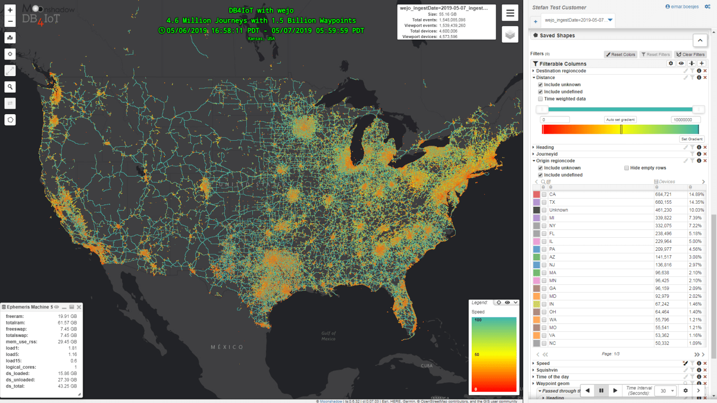
DB4IoT with Wejo data is available for any area in the US
DB4IoT = PaaS: No servers or IT staff required
DB4IoT with Wejo Journeys is offered as a Platform as a Service (PaaS) in the cloud. DB4IoT does not increase the workload of your IT staff; planners and traffic engineers access the data from a web interface without having to rely on IT staff or database engineers. There is no need to store and process large databases on your own servers. Easily export project data to import into other analytical tools you already use.
Live Traffic
DB4IoT can be used by traffic operations centers to monitor vehicle movement in real time. Depending on the area DB4IoT can provide maps showing 95% of the Wejo movement data in 120 seconds or less. DB4IoT will show exactly where on a segment traffic is stopped and how far it is backing up. This information is invaluable for DOTs and traffic management organizations. Real-time data can be combined with historic data to compare the current situation to the normal situation for the same day and time.

An Origin/Destination table is generated after selecting a road segment
Intuitive, easy-to-use browser interface
Filter and select data for any area and time range from DB4IoT’s intuitive point-and-click, map-based user-interface. Define your own peak periods and days of interest and combine these with polygon filters for origins, destinations or waypoints. Easily create maps, charts and graphs for use in reports and presentations. Generate tables with travel times and speeds and export these as CSVs. Create movement animations. Display the data over maps and satellite layers as you analyze the data.
Harsh Breaks, Fast Accelerations
Wejo Events includes harsh breaks and fast accelerations. Locations with a high frequency of these events indicate dangerous road conditions. DB4IoT can provide historic feeds or next day feeds for Wejo Events. The events data can be overlaid over the Wejo Journey data to compare vehicle movement and harsh breaks and accelerations for the same time and area.

Vehicles visualized by speed; Wejo receives an update from 14 million vehicles every three seconds
Unsurpassed Data Precision
Wejo receives an update from 14 million vehicles in the US every three seconds. The high frequency allows Wejo to correct the GPS inaccuracies. The result is a data set that is so precise that you can often see what lane a vehicle is driving in or how long the wait time is at a drive through. Where other connected vehicle data shows travel times or speeds per road segment, DB4IoT with Wejo journeys shows the speed variations within a road segment.
Compatible with data from many software solutions and file formats
DB4IoT can combine a variety of data sources with Wejo Journeys; Transit data, Fleet data, Census data, demographics, weather and more, including your own data. Wejo Journeys provides the most complete view of actual observed trips drivers take, including anonymized starts and ends of their journeys and the waypoints in between. Trips insight is derived from industry-leading geospatial data processing, which enables new understanding of population movement information such as origin and destination zones, diversion routes during peak time and incidents, corridor usage and more.