ITS Washington Annual Meeting Presentation – Using Connected Vehicle Data to Estimate Greenhouse Gas Emissions

By |2021-07-01T17:23:14+00:00December 19, 2018|DB4IoT News, DB4IoT with INRIX Trips, The Internet of Moving Things, Uncategorized|

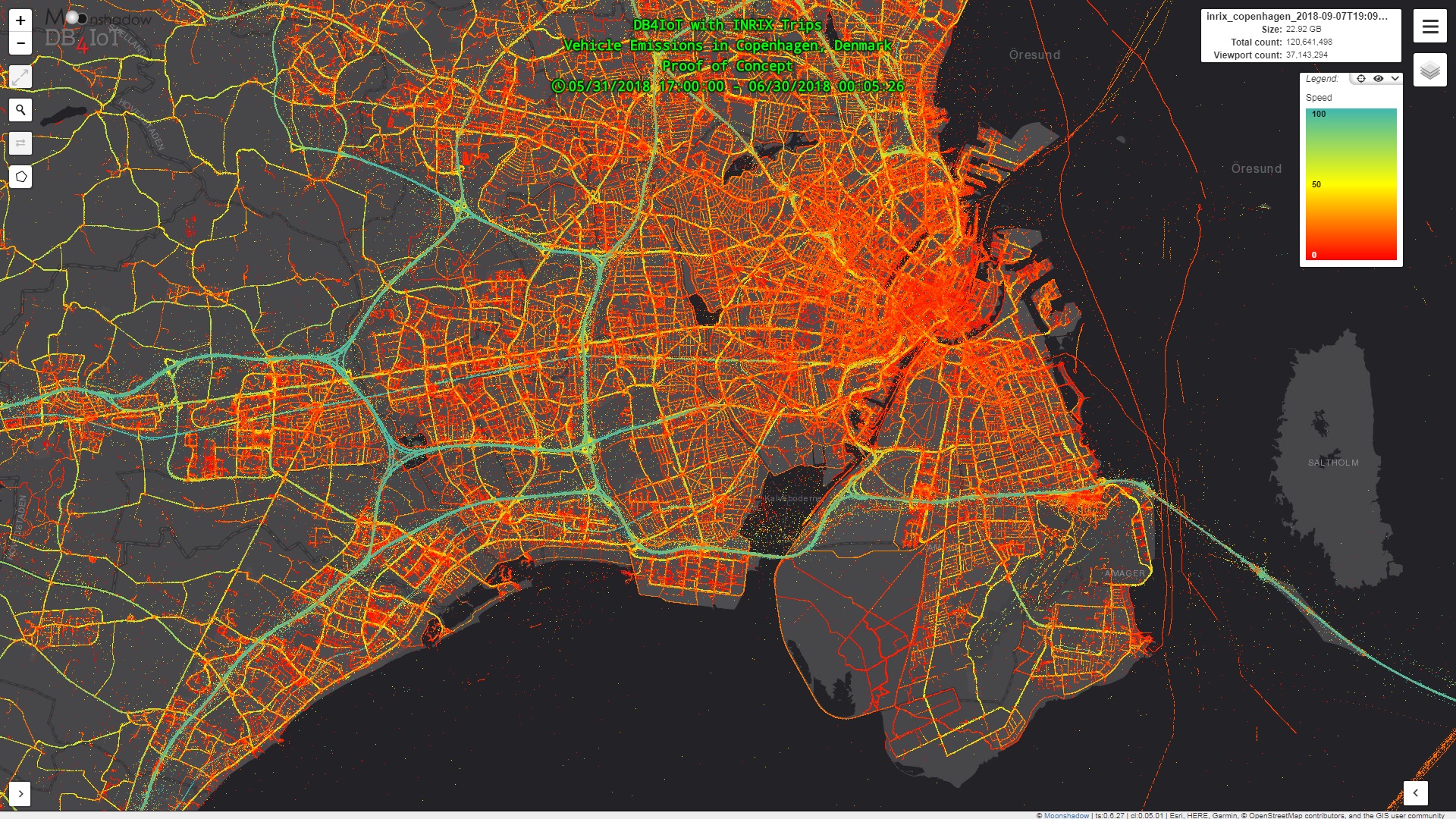
Eimar Boesjes, Moonshadow CEO, delivered a technical presentation at the ITS Washington annual meeting on December 11th, 2018 in Seattle.Estimating vehicle emissions from connected vehicle data does not replace existing environmental models, roadside emissions measurements or environmental models. Rather, it augments these. We think it would be extremely interesting to compare the emissions estimates from DB4IoT with INRIX Trips with actual measurements from roadside air quality measurements, with emissions calculations from gasoline sales and with the existing environmental models. These different approaches each give a different insight and [...]

Comments Off on ITS Washington Annual Meeting Presentation – Using Connected Vehicle Data to Estimate Greenhouse Gas Emissions

Deriving Greenhouse Gas Emissions Estimates from Connected Vehicle Data

By |2021-07-01T17:46:11+00:00October 31, 2018|DB4IoT News, DB4IoT with INRIX Trips, The Internet of Moving Things|

Eimar M. Boesjes, CEO, Moonshadow Mobile Joshua Skov, Industry Mentor, Lundquist College of Business, University of Oregon October 26, 2018 What does the carbon footprint from transportation look like? In particular, how could you map it? Typically, carbon footprinting exercises for local and regional jurisdictions deliver highly aggregated results. Even when the unit of analysis is geographic, the data is all about pie charts and tables. The results for New York City are...for all of New York City. Meaningful and important, but it leaves us missing something truly geographic [...]

Comments Off on Deriving Greenhouse Gas Emissions Estimates from Connected Vehicle Data

Making Better Transit Planning Decisions by Identifying ITS Data Errors

By |2021-07-01T20:30:42+00:00April 13, 2018|DB4IoT News, Route Analyst GTFS, The Internet of Moving Things, Uncategorized|

Over the last few decades public transit agencies have installed CAD/AVL systems on their buses for Computer Aided Dispatch and Automatic Vehicle Location. CAD/AVL systems capture data measurements of the location of the bus, number of passengers, delay, speed and many other variables, often as frequently as every five seconds. The result is a huge trove of data that can provide a wealth of information and insights about the operation of a transit agency. Data in these large quantities, however, always contains a significant number of errors. If charts, graphs [...]

Comments Off on Making Better Transit Planning Decisions by Identifying ITS Data Errors

Route Analyst GTFS Presentations in Seattle

By |2021-07-01T20:42:50+00:00December 13, 2017|DB4IoT News, Route Analyst GTFS, The Internet of Moving Things|

Moonshadow CEO, Eimar Boesjes, introduced Route Analyst GTFS to a number of transit agencies and ITS professionals from the greater Seattle area on December 11th and 12th. Our partners at DKS Associates hosted a session at their offices on the 11th and Boesjes demoed the technology at the ITS Washington vendor showcase held at the University of Washington HUB on the 12th. Route Analyst GTFS creates speed, delay and headway maps, charts and graphs instantly from your GTFS and GTFS-RealTime feeds. Route Analyst GTFS is cloud-based database and analytics software [...]

Comments Off on Route Analyst GTFS Presentations in Seattle

Route Analyst GTFS Released for Three Agencies in Greater Seattle Area

By |2021-07-15T17:30:07+00:00November 30, 2017|DB4IoT News, Route Analyst GTFS, The Internet of Moving Things|

Route Analyst GTFS has been released for the following three agencies in the Greater Seattle area; King County Metro (KCM), Pierce County and the Washington State Ferries. KCM provides public transit throughout the greater Seattle region servicing towns from Lake Forest Park and Bothell in the North to Kirkland, Redmond and Bellevue in the East and Burien, Tukwila, Renton, Federal Way and Auburn in the South. Pierce Transit covers the greater Tacoma area and the WA State Ferries link many of the islands in the Puget Sound and in [...]

Comments Off on Route Analyst GTFS Released for Three Agencies in Greater Seattle Area

Route Analyst GTFS Released for RTD Denver

By |2021-07-15T17:26:39+00:00November 28, 2017|DB4IoT News, Route Analyst GTFS, The Internet of Moving Things|

Moonshadow Mobile has released DB4IoT Route Analyst GTFS for the Regional Transportation District (RTD) in Denver, Colorado. The RTD provides public transit throughout the greater Denver region servicing towns from Longmont, Boulder and Lafayette in the North to Sheridan, Englewood, Aurora, Littleton and Centennial and all the way to Parker, CO, in the South. The RTD makes its schedule available as a GTFS file whenever the schedule changes. The RTD also publishes the movement of all its buses and trains in real-time as a GTFS Real Time Vehicle Position file. [...]

Comments Off on Route Analyst GTFS Released for RTD Denver

Presentation at Rail~Volution Conference Big Data Panel

By |2021-07-01T22:16:39+00:00September 12, 2017|DB4IoT News, The Internet of Moving Things, Uncategorized|

Join Moonshadow CEO Eimar Boesjes on Monday, September 18th (Noon - 1:30 pm) for a lively panel discussion and presentation at the Rail~Volution Conference in Denver, CO. Boesjes presentation will focus on analyzing public transit data and how Internet of Moving Things data analytics and visualization delivers important benefits to public transit agencies and helps build livable communities. Download and view the DB4IoT Rail~Volution presentation here: PowerPoint PDF Document Rail~Volution is four days of energizing events that connect citizen activists, developers, nonprofit and business leaders, planners, local elected officials, community [...]

Comments Off on Presentation at Rail~Volution Conference Big Data Panel

Presentation to Portland TransPort

By |2021-07-01T22:24:20+00:00July 17, 2017|DB4IoT News, The Internet of Moving Things, Uncategorized|

Moonshadow’s CEO, Eimar Boesjes, delivered a presentation last week to TransPort, a subcommittee of TPAC (the Portland, OR region’s Transportation Policy Alternatives Committee). TransPort is a regional forum for cooperative planning and deployment of new transportation system management and operations technologies. Boesjes teamed up with A.J. O’Connor and Steve Callas from TriMet on a panel discussion about transit data in DB4IoT and the different ways to look at transit data to improve system operations. An example of the collaborative efforts between Moonshadow, TriMet and DKS Associates was discussed with those [...]

Comments Off on Presentation to Portland TransPort

Making Traffic Data Accessible

By |2021-07-01T22:32:32+00:00June 23, 2017|DB4IoT News, The Internet of Moving Things, Uncategorized|

Moonshadow Mobile has developed DB4IoT, a database engine purpose-built for the Internet of Moving Things (IoMT). Last week, Moonshadow’s CEO, Eimar Boesjes, presented DB4IoT at NAAUM 2017, the North American Aimsun Users' Meeting in Portland, Oregon. Moving vehicles generate enormous amounts of data. IoMT data isn’t Big Data, it is Bigger Data. To look at moving vehicles at a resolution of less than one meter of movement you need 50 measurements per second. At this rate a single car generates 180,000 timestamped records per hour of driving. To look at [...]

Comments Off on Making Traffic Data Accessible

Route Analyst CAD/AVL: Creating Speed and Delay Maps from CAD/AVL Data

By |2021-07-01T23:41:41+00:00May 19, 2017|DB4IoT News, The Internet of Moving Things, Uncategorized|

Route Analyst CAD/AVL is a breakthrough technology that gives transportation engineers and planners the ability to view hundreds of millions of movement points instantly and show exactly when and where traffic is slowing down bus movement and creating service delays. Public transit agencies are tasked with moving as many passengers as possible from one place to another as quickly and predictably as possible. It is very important for transit agencies to understand how well they are performing this task and how they can improve travel times and predictability. With Route [...]

Comments Off on Route Analyst CAD/AVL: Creating Speed and Delay Maps from CAD/AVL Data
Go to Top